PLSS in Google Earth (PLSGE)
The BLM server will reject image requests from older versions of Google Earth, causing the Townships and Special Surveys overlays to display a big red X instead of PLSS images. To work around this issue, use the Google Earth link above to install the latest version.
The principal component of PLSGE is a Google Earth implementation of the Public Land Survey System (PLSS) Cadastral National Spatial Data Infrastructure (PLSS CadNSDI) map service that retrieves multiresolution images of the PLSS from the Bureau of Land Management (BLM).
- Position the area of interest (AOI) in the viewer.
- Check the radio button beside the Meridians, Townships, or Special Surveys network link. Use the Townships overlay to find townships and sections. Use the Special Surveys overlay to find other divisions.
- On subsequent uses, reposition the AOI and ensure that the network link is checked and selected. When Refresh Mode is Automatic, the overlay is refreshed two seconds after camera movement stops. When Refresh Mode is Manual, choose Refresh from the Edit menu, or right-click and select Refresh in the context menu (explain).
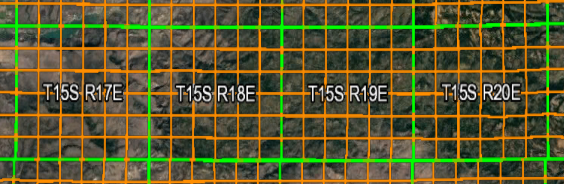
Coverage includes Alabama, Alaska, Arizona, Arkansas, California, Colorado, Florida, Idaho, Illinois, Indiana, Iowa, Kansas, Louisiana, Michigan, Minnesota, Mississippi, Missouri, Montana, Nebraska, Nevada, New Mexico, North Dakota, Ohio, Oklahoma, Oregon, South Dakota, Utah, Washington, Wisconsin, and Wyoming.
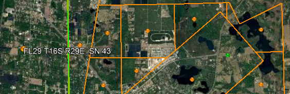
PLSGE also includes a facility to draw approximate PLSS boundaries with links to BLM land records.
SECTION GEOCODER
Point SearchThe Point Search network link is a Google Earth implementation of the PLSS CadNSDI query service. This feature should be used in conjunction with the Townships overlay to ensure that the point of interest (POI) is contained within a first division boundary.
- Position the POI in the center of the view. One way to do this is to double-click an unmarked location. To precisely position the POI in the center of the view, add a placemark at the desired location; then edit the properties of that placemark and reset the view (explain). For best results, disable automatic tilting (Tools, Options, Navigation, Do not automatically tilt while zooming) and minimize elevation exaggeration (Tools, Options, 3D View, Elevation Exaggeration, 0.01).
- Check the box beside the Point Search network link. The section boundary that contains the POI will be added to the Search Results folder. A successful point search will also update initial values in the TRS Search form.
- On subsequent uses, reposition the POI and ensure that the network link is checked and selected. Then choose Refresh from the Edit menu, or right-click and select Refresh in the context menu (explain).
TRS Search
The TRS Search network link is a Google Earth implementation of the PLSS CadNSDI query service. This feature should be used in conjunction with the Townships or Special Surveys overlay to ensure that the requested township, section, second division, or special survey exists. Use the Townships overlay to find townships and first divisions. Use the Special Surveys overlay to find other divisions.
- Optionally, use the Point Search network link to preset initial values to the section level.
- Click on the TRS Search folder name to open a form with input fields for state, meridian, township, range, section, second division, and special surveys. Mouse-over input fields for brief instructions.
- Press the Search button on the input form to add the requested parcel to the Search Results folder.
All images and data are retrieved from remote servers. Data errors, accuracy, and availability are beyond the control of this application.