National Geodetic Survey Control Stations (NGSCS)
NGSCS creates Google Earth network links that plot the approximate location of NGS control stations within a specified distance of the view center (Radial Search), within the viewer bounding box (Rectangular Search), or within a selected county (County Search). Station balloons contain all information supplied by the NGS station list server and a hyperlink to the full NGS datasheet.
Click on Query Setup to open a form with input fields for search type, station type, station stability, radius, and county. The requested search is added to the Saved Searches folder when the OK button is pressed.
RADIAL SEARCH
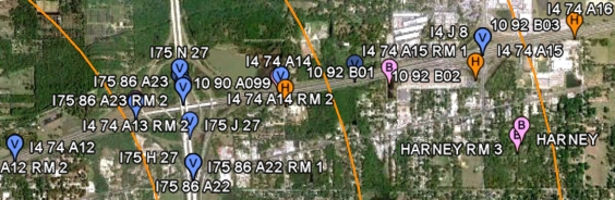
NGSCS Radial Search creates a Google Earth network link that plots the approximate location of NGS control stations within a specified distance of the view center (Fig. 1). See NGS Datasheets for a list of supported locations.- Position the point of interest (POI) in the center of the view. One way to do this is to double-click an unmarked location. To precisely position the POI in the center of the view, add a placemark at the desired location; then edit the properties of that placemark and reset the view (explain). For best results, disable automatic tilting (Tools, Options, Navigation, Do not automatically tilt while zooming) and minimize elevation exaggeration (Tools, Options, 3D View, Elevation Exaggeration, 0.01).
-
Check the box beside the Search Results network link.
Range rings and station markers should appear within two minutes.
- H = Horizontal only
- V = Vertical only
- B = Both horizontal and vertical
- On subsequent uses, reposition the POI and ensure that the network link is checked and selected. Then choose Refresh from the Edit menu, or right-click and select Refresh in the context menu (explain).
The radius, station type, and station stability are selected in the Query Setup form. Radii up to 10 miles are permitted, but the NGS server will not retrieve a list with more than 3000 stations.
RECTANGULAR SEARCH
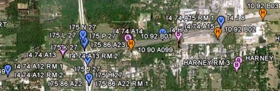
NGSCS Rectangular Search creates a Google Earth network link that plots the approximate location of NGS control stations within the viewer bounding box (Fig. 2). See NGS Datasheets for a list of supported locations.- Position the area of interest (AOI) in the viewer.
-
Check the box beside the Search Results network link.
Station markers and the AOI rectangle should appear within two minutes.
- H = Horizontal only
- V = Vertical only
- B = Both horizontal and vertical
- On subsequent uses, reposition the AOI and ensure that the network link is checked and selected. Then choose Refresh from the Edit menu, or right-click and select Refresh in the context menu (explain).
The station type and station stability are selected in the Query Setup form. Areas up to 20' x 20' (arc minutes) are permitted, but the NGS server will not retrieve a list with more than 3000 stations.
COUNTY SEARCH
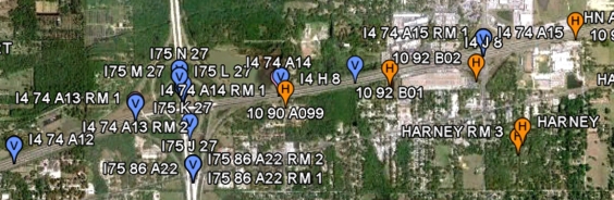
NGSCS County Search creates a network link that plots the approximate location of NGS control stations within a selected county (Fig. 3). See FIPS Codes for a list of supported locations.-
The County Search network link is activated when it is first loaded.
Station markers should appear within two minutes.
- H = Horizontal only
- V = Vertical only
- B = Both horizontal and vertical
- To update the county search, ensure that the network link is checked and selected. Then choose Refresh from the Edit menu, or right-click and select Refresh in the context menu (explain).
County searches do not currently recognize tanks or towers as horizontal marks. To visualize horizontal stations, plot all marks and uncheck the Vertical folder. Destroyed marks and marks with incomplete datasheets are not reported by county searches, nor do county searches assign vertical order to horizontal control stations with NGVD29 heights.
The county, station type, and station stability are selected in the Query Setup form.
Note: To save search results from one Google Earth session to another, open the Search Results folder, right-click on Stations, and select Save to My Places or Save Place As.
See NGS Station List for source data. All data are retrieved from remote servers. Data errors, accuracy, and availability are beyond the control of this application.